West Texas LiDAR Project
West Texas LiDAR Project
The West Texas LiDAR project was completed for the USGS in 2019. The data can be accessed in Equator by clicking below.


The West Texas LiDAR Project
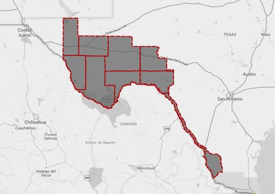
The West Texas LiDAR project was completed between February 16 and May 14, 2019. The following counties were included in the survey: Culberson, Jeff Davis, Reeves, Presidio, Brewster, Pecos, Terrell, Val Verde, Crockett, Crane, Ward, Maverick, Dimmit, Kinney, Webb, Zapata, and Jim Hogg. The survey was ordered to support the Federal Emergency Management (FEMA) Risk Mapping, Assessment, and Planning (MAP) program, the National Resources Conservation Service (NRCS) high resolution elevation enterprise program, and the 3DEP mission.
LiDAR Data Collection
In total, 32,494 square miles were surveyed as part of the West Texas LiDAR acquisition project. The survey was completed by a joint venture of Merrick-Surdex. Point cloud data was collected using Optech Galaxy lidar sensors. The Galaxy is a high performance sensor that is capable of surveying large areas efficiently.


LiDAR Data Accuracy
The survey was completed to a quality level of 2 (QL2) in accordance with USGS Lidar Base Specification 1.3. After the survey was complete, a vertical accuracy control report was prepared to summarize the non-vegetated vertical accuracy (NVA) and vegetated vertical accuracy (VVA). The NVA and VVA were tested to be 11.2 cm (4.4 inches) and 20.8 cm (8.2 inches), respectively, to a 95% confidence level.
Texas Cities/Towns covered in the LiDAR Survey
As part of the West Texas LiDAR survey, the following cities/towns were included:
- Nuevo Laredo
- Elm Creek
- Del Rio
- Sanderson
- Marathon
- Alpine
- Marfa
- Fort Davis
- Balmorhea
- Grandfalls
- Coyanosa
- Fort Stockton
- Sheffield
- Iraan


What if this LiDAR doesn’t cover my project site?
If you are looking for topographic data that falls outside of the West Texas project extents, please check out the USGS Topographic Map page for more information.
Why should I use Equator to access the West Texas LiDAR Survey?
Centimeters of accuracy from your home or office, in-real time
Find topographic data in your area using the built in search engine
Combine LiDAR data with your own on our innovative 3D mapping platform
The post West Texas LiDAR Project appeared first on Equator .
Full content in Equator Studios

