Orienteering Map Maker
Orienteering Map Maker
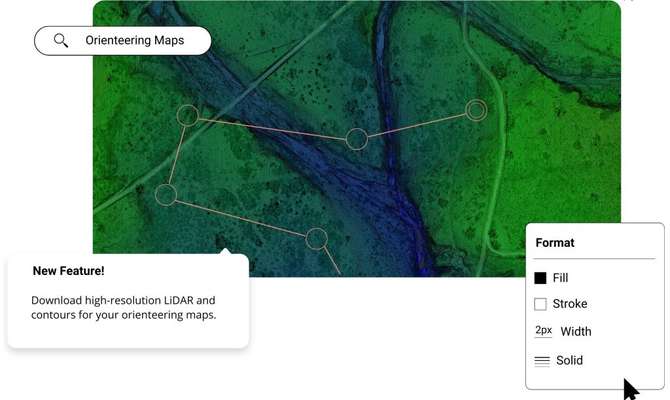
Create high-resolution orienteering maps and figures in minutes using the online LiDAR data, in the Equator platform.

Join other leading designers on Equator.


Create an orienteering map in Equator
- Navigate to your location of interest
- Add contours, LiDAR, or hillshades to your site
- Add markups, icons and measurements to your orienteering map
- Format your orienteering map
- Share your orienteering map with others online or in print


Integrate your map with other software
We’ve made it easy to integrate into your current workflow to get you up and running without friction.
Equator supports popular GIS and CAD data formats, so map layers like LiDAR can be easily exported to Civil 3D, ArcGIS, Google Earth, or other platforms.
How to Get Started

Step 2
Create an account by signing up with your favorite email address.

Step 3
Use the built-in search engine and design tools to find elevation data and build your map.
Frequently Asked Questions
Orienteering is an outdoor sport that involves using a map and compass to navigate through a series of checkpoints in the shortest amount of time possible. Orienteering is a sport that is commonly enjoyed by engineers and students. It is a great way to get outside and explore your surroundings. Orienteering can be done solo or in a group, and it’s a perfect activity for anyone who loves to hike or run. If you’re looking for a new outdoor challenge, give orienteering a try!
Orienteering is a sport that can be enjored by people of all ages and abilities with minimal equipment. Find a local orienteering club in your area and get started!
It’s been around for centuries, and has origins in both Sweden and Norway.
Orienteering maps can be made using equator studios software in your browser. Click here to make one now.
The post Orienteering Map Maker appeared first on Equator .
Full content in Equator Studios

