Golf Map App
Golf Map App
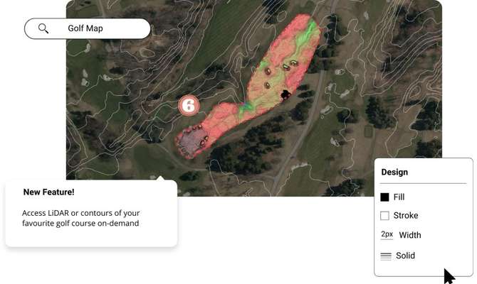
Create golf maps and figures in minutes using the best elevation data online, in the Equator platform. Share maps with others instantly.

Join other leading designers on Equator.


Create a golf map in Equator
- Navigate to your location of interest
Add contours, LiDAR, or hillshades to your site
- Add markups, icons and measurements to your golf map
- Take detailed measurements of the golf course
Share your golf maps with others online or in print


Integrate your map with other software
We’ve made it easy to integrate into your current workflow to get you up and running without friction.
Equator supports popular GIS and CAD data formats, so map layers like LiDAR can be easily exported to Civil 3D, ArcGIS, Google Earth, or other platforms.
How to Get Started

Step 2
Create an account by signing up with your favorite email address.

Step 3
Use the built-in search engine and design tools to find elevation data and build your map.
Frequently Asked Questions
A golf map shows the layout of the holes on the course. This includes the distance to the tee, the par, the location of the tea, green and fairway as well as the route a golfer should take to reach each hole.
Golf maps can be made in Equator using our design tools to customize and export the map for use elsewhere. Click here to try Equator for free.
Golf maps can vary in accuracy. Some maps used can have a vertical accuracy of up to 10cm.
Golf maps are used by golfers looking to navigate the golf course. From the tee, you can’t always see the exact layout of the course. Using a golf map, a golfer can determine their best course of action before taking their shots.
The post Golf Map App appeared first on Equator .
Full content in Equator Studios

